Dagri Bangla Trek
23rdJune 2021
Dagri Bangla rest house is located deep within the dense forest of the Galiyat region. Despite being abandoned and structurally damaged, it is a popular destination for hikers and backpackers for a weekend hiking and camping trip.
Dagri Bangla's location is incredibly serene and peaceful due to its remoteness. It is the ideal weekend getaway from the hustle and bustle of civilisation.
Jump to:
- Hike Overview
- Dagri Bangla Trek Map
- Trip Overview
- How to Reach
- Hike to Dagri Bangla
- Camping
- Equipment
- Trail Video
Hike Overview
- Hike Difficulty: Moderate
- Trail Length : 14 km (8.7 mi)
- Typical Hike Duration (One-way): 6.5 hours
- Elevation Gain: 614 m (2,014 ft)
- Max Altitude: 2,971 m (9,747 ft)
- Water Availability: None
- Trailhead: Miranjani Trek Starting Point, Namli Maira
- Trailhead Altitude: 2,357 m (7,733 ft)
- Campsite: Dagri Bangla
- Guide: Usually available from near the Trailhead
- Porters: Usually available from near the Trailhead
- Car Parking: Available at trailhead on weekends
Note: Preserving nature is the responsibility of every tourist / hiker. Please DO NOT LITTER, DO NOT DRAW GRAFFITI, DO NOT CUT TREES.
Dagri Bangla Trek Map
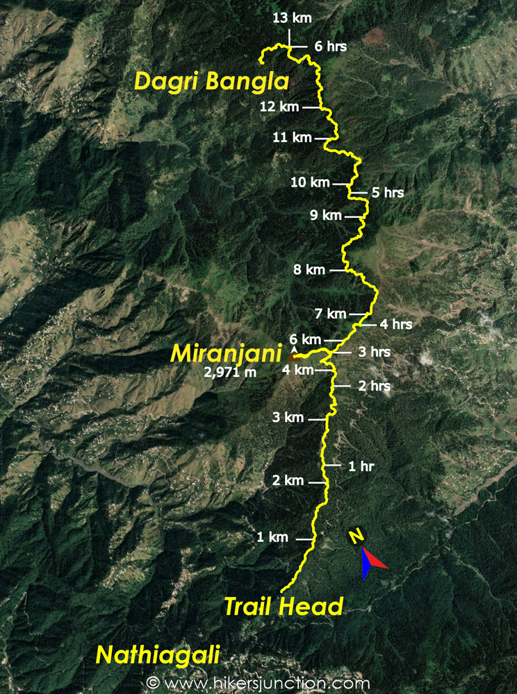
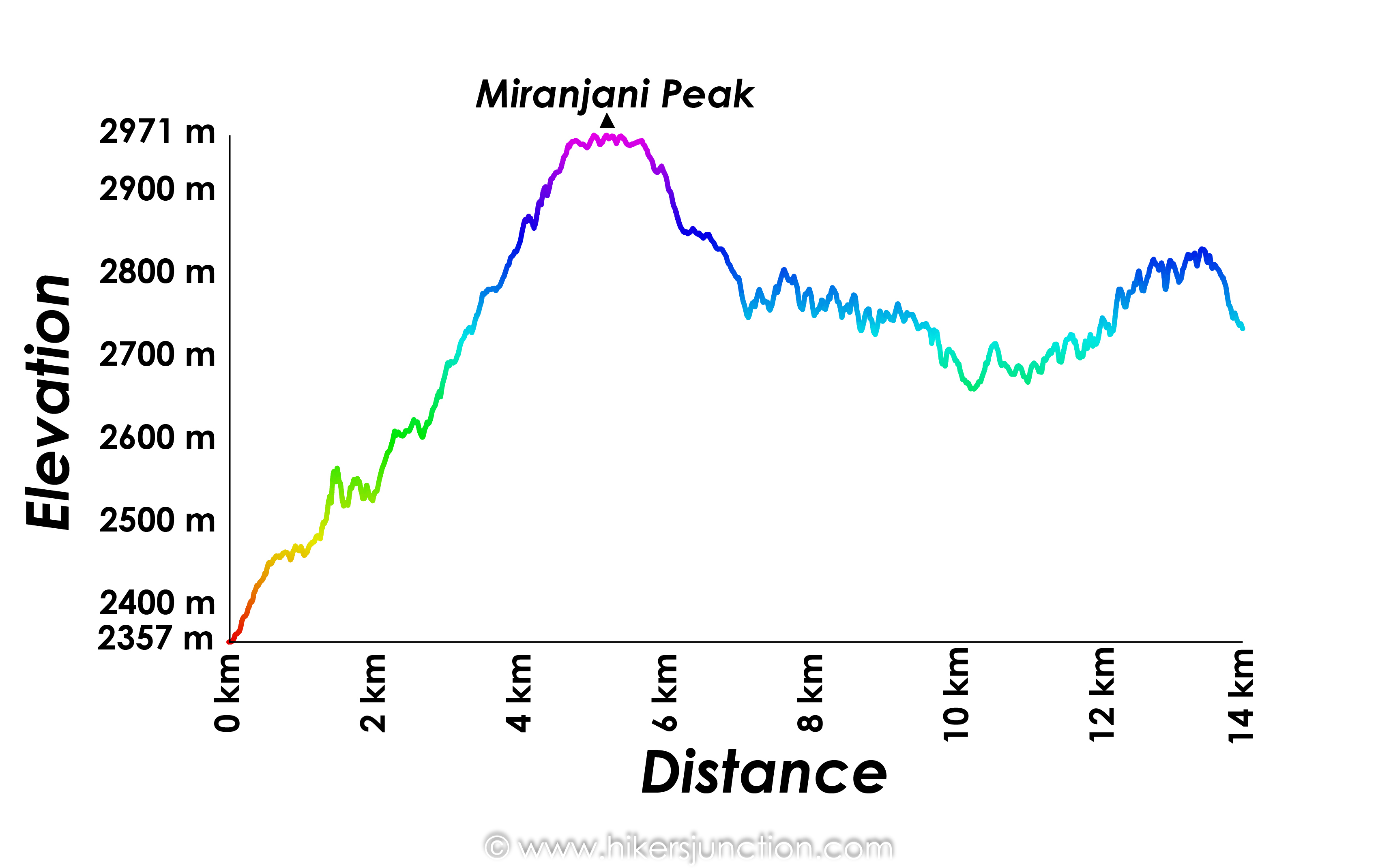
Trip Overview & Itinerary
| Day | Time | Journey | Duration |
|---|---|---|---|
| Day 1 | 08:00am to 11:00am |  Islamabad to Nathiagali |
3 hours |
| 11:30am to 02:30pm |  Nathiagali to Miranjani |
3 hours | |
| 03:00pm to 05:30pm |  Miranjani to Dagri Bangla |
2.5 hours | |
| Day 2 | 07:00am to 09:30am |  Dagri Bangla to Miranjani |
2.5 hours |
| 10:00am to 12:00pm |  Miranjani to Nathiagali |
2 hours | |
| 01:00pm to 04:00pm |  Nathiagali to Islamabad |
3 hours |
Useful Tips
- There is no easily accessible water source on this hike. Hence, carry at least 3 litres of water for the roundtrip. Try not to consume more than 1.5 litres on the way to Dagri Bangla. There is a seasonal water spring slighly further ahead of the bangla but it is out of way and unreliable.
- Dagri Bangla weather is highly unpredictable, always carry appropriate gear for protection against rain such as raincoat, rucksack cover and waterproof shoes.
Reaching Dagri Bangla's Starting Point
Me and a couple of my friends hathed a plan to escape the June heat of Islamabad and spend the weekend hiking in Nathiagali. Our destination was Dagri Bangla. Some years back we had attempted to go to the Bangla but we could only make it to Miranjani peak before the weather turned on us. This time around we made all necessary preparations.
We set off from Islamabad on Saturday at 8am, taking the Murree Expressway till Dunga Gali. The starting point of the trek can be reached by taking a right just before Nathiagali bazaar towards the governer house and church. We headed past the church and a few turns later we saw the solitary hut which marks the start point. The concrete steps towards the right side of the hut are the Miranjani / Dagri Bangla trek start point.
Hike to Dagri Bangla
The trail to Dagri Bangla can be considered as having two sections. The first section is till the Miranjani peak and the second section is till Dagri Bangla.
For the first section, the trail starts off with a few concrete steps leading into the forest. The trail levels ever so slighlty before becoming steep for the initial 1 km of the hike. At the end of this first ascent the trail becomes flat and you can enjoy a pleasant walk through the woods with decent views of the surrounding hills.
At the first split in the trail we took the path on the right. This path lead to the small pond past which there was a guy selling tea and snacks. Miranjani Peak and its iconic steel pillar is visible from this point in the distance straight up ahead.
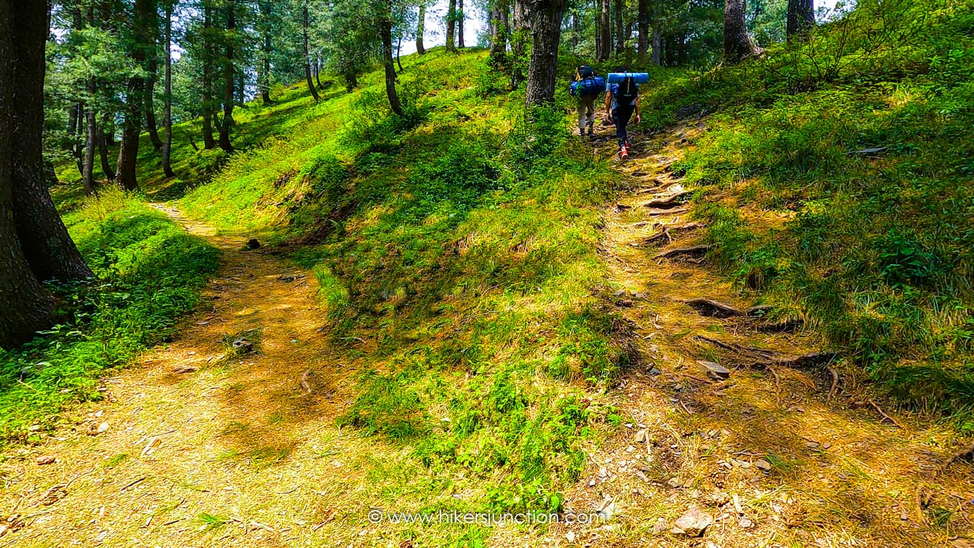
As we proceeded into the trail, the chirping of the birds became more and more noticable. The trail is pretty straightforward up until near the very top where there is another split in the trail. The path to the left leads to the Miranjani Peak whilst the path straight up ahead leads to Dagri Bangla.
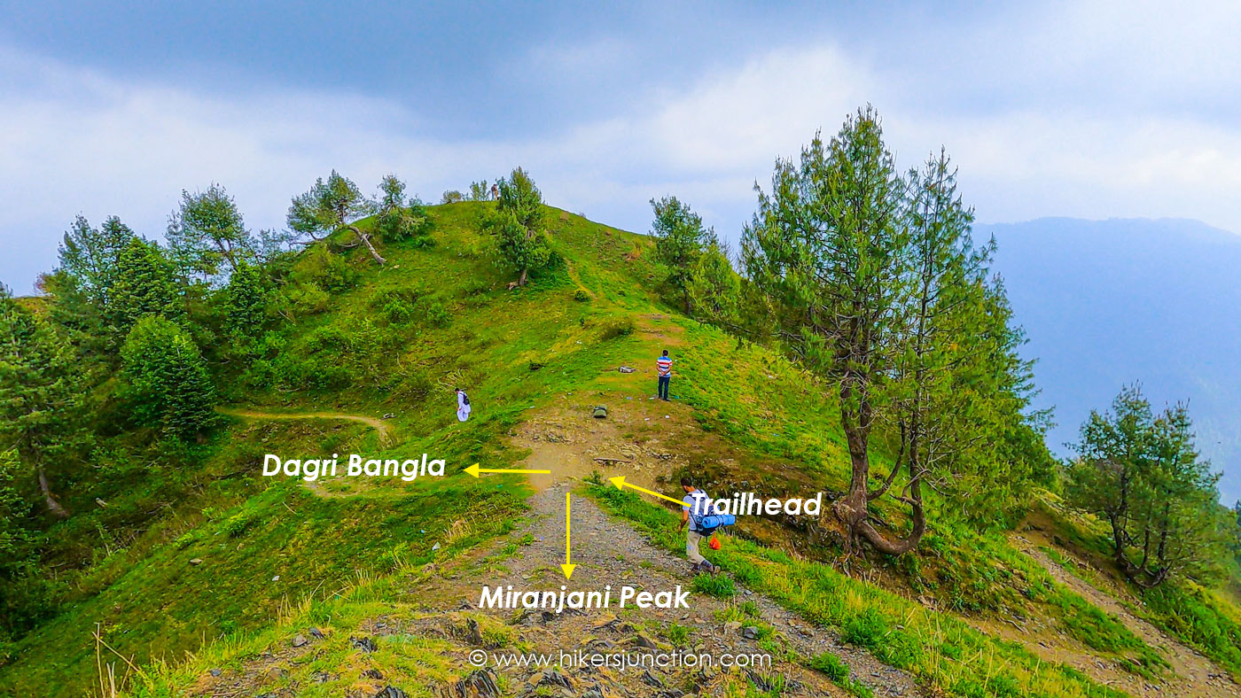
We decided to 'summit' Miranjani since we were so close to it. We turned left and in about 7-8 mins we reached the peak. It took us 3 hours to reach Miranjani from the trailhead, of course we were carrying rucksacks which slowed us down considerably.
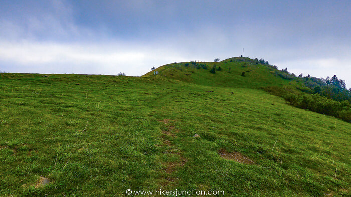
After resting at Miranjani for a little while, we proceeded towards Dagri Bangla. For this second section to Dagri Bangla, we descended down through a hilly meadow. After about 20mins we once again came across a junction with several paths. The flat path to the left heads to Dagri Bangla and rest lead to nearby villages.
From this point the weather took a turn for the worst and it started raining heavily. Luckily all of us came prepared for this. We toiled through heavy rain for about 2 hours to cover the 8.5 km to Dagri Bangla through a mostly flat trail.
Even with the heavy rain, this stretch of the hike was undoubtedly the highlight of the trip. The trail was fairly narrow with a lot more vegetation. The pine forest was really dense and there was more wildlife here. This was mostly evident by the incredible continuous chirping sounds of the birds. The hike to Dagri Bangla Nathiagali is definitely about the journey instead of the destination. It should also be noted that this region is home to the nocturnal common leopard. For this reason, the trail must be avoided at night for the safety of both humans and animals.
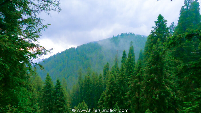
Along the way there were several small meadows where the forest canopy opens up.
The first sign that we had nearly reached the Bangla was a board stuck to a tree on the left which indicated so. We turned left here and a minute or two later the Bangla came into view on our left.
Although it is highly unlikely for one to miss the board and carry on straight, it should still be mentioned that the trail extends for much longer on the other side of the Bangla towards Thandiani. Hence, not spotting the board, however unlikely, could prove to be a grave mistake.
Camping at Dagri Bangla
After hiking 14 km in about 6 to 7 hours, we reached the abandoned forest rest house. Dagri Bangla's history goes back to the time of the British but it was evident that its best days were surely behind it. The bangla did not seem maintained since there was some structural damage which was not repaired. To our surprise the grounds of the Bangla was really busy. There were about 15 tents already pitched there. We picked an available spot and pitched our tent.
It is important to bring your own camping gear since it is not available for hire at the campsite
However, some locals provide services at the campsite such as fetching water from a nearby spring or setting up a fire for cooking etc.
After resting for a while, we prepared our dinner on an open fire and then went to sleep.
Waking up early morning is a must when you are visiting Dagri Bangla. Early in the morning the sounds of the birds are like nothing I have ever experienced before. I took in the amazing sounds and sights of nature before taking breakfast and heading back down to civilisation.
Available Facilities at Campsite
| Facilities | Availability |
|---|---|
| Tents |  |
| Water |  |
| Food |  |
| Toilet |  |
| Phone Signals | limited |
Trail Video
Other Hikes
Check out similar blog posts on many other hikes here.
Equipment
Having the right equipment and gear is essential for an enjoyable hiking experience. Check out the list of recommended hiking gear.


